Atlantic Hurricane Season Heats Up: Three Disturbances Under Watch
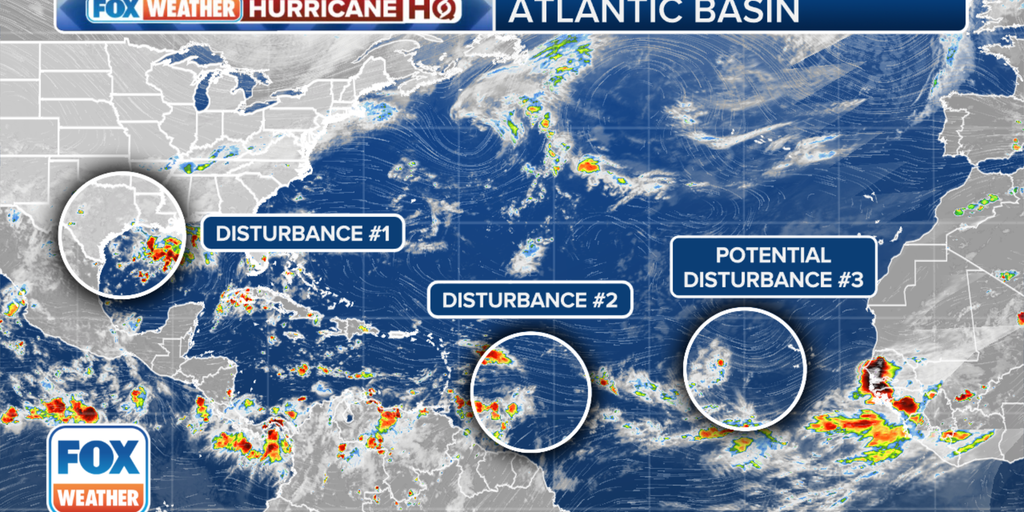
As we move deeper into the Atlantic hurricane season, the National Hurricane Center (NHC) has shifted its focus to three developing weather disturbances across the Atlantic and the Gulf of Mexico. This heightened activity signals a potentially busy week ahead as we monitor these systems for possible tropical development.
The first area of concern lies a few hundred miles east of the Lesser Antilles in the central Atlantic. While this disturbance hasn’t shown significant changes in organization since Saturday, it remains the primary focus for forecasters. The NHC has projected that this system will move westward, reaching the Lesser Antilles by Monday and then advancing into the eastern Caribbean by Tuesday. The conditions are expected to become more favorable for development as the system traverses the warmer waters of the Caribbean later in the week. There is a moderate 40% chance that this disturbance could evolve into a tropical depression as it moves across the central and western Caribbean Sea.
Also Read:- ABBA Requests Trump to Stop Using Their Music Amid Dispute Over Licensing
- Germany's Far-Right AfD Secures Historic Win, Signaling Rising Discontent
Meanwhile, a second area of interest is situated in the Gulf of Mexico, near the coasts of Texas and Louisiana. This disturbance, characterized by a broad area of low pressure, has been generating widespread thunderstorm activity both along and just offshore. Although the NHC currently assigns it a low chance of development—10% over the next 48 hours and the next seven days—there remains a risk of heavy rainfall and flash flooding in the coastal regions. The system is expected to linger near the coast through much of the upcoming week, with slow tropical development possible if it stays offshore over the warm Gulf waters.
Lastly, the NHC is also monitoring a tropical wave that is currently moving over western Africa. This system is projected to move offshore on Monday, entering the eastern tropical Atlantic. While the current chances of development are low—near 0% in the next 48 hours and 20% over the next seven days—forecasters will keep a close eye on this disturbance as it progresses westward or west-northwestward.
The 2024 Atlantic hurricane season, though quiet so far, is entering a phase where conditions are becoming more conducive to storm development. The NHC's predictions suggest that we could see an increase in tropical storm activity as we move further into the season. As always, residents in hurricane-prone areas should stay informed and be prepared for any potential impacts from these developing systems. The situation is fluid, and the outlook could change as new data becomes available, making it crucial to monitor updates from trusted sources like the National Hurricane Center and local weather services.
Read More:

0 Comments