

South Florida Faces Scorching Heat and Storms Today
Today’s weather in South Florida is set to bring a blend of intense heat and scattered storms. As the sun rises over our region, temperatures are already starting to climb, with the mercury expected to hit well over 100 degrees later in the day. For those planning to be outside, it’s important to stay hydrated and seek shade whenever possible to avoid heat-related issues.
The current temperature is around 82 degrees, and while it might feel relatively comfortable for now, the heat will intensify as the day progresses. In Palm Beach County, for example, temperatures could soar above 105 degrees. This has prompted a heat advisory to go into effect at 10 a.m. today. If you’re in this area, be prepared for a prolonged period of extreme heat.
In addition to the sweltering conditions, we’re also expecting a few spotty showers throughout the region. Early morning light rain has already been reported along Jupiter Island and Hobe Sound, with more scattered showers stretching from Lake Worth Beach to Boca Raton. These showers may offer brief relief from the heat, but they won’t be enough to significantly lower the overall temperature.
Also Read:- Ja'Marr Chase's Status for Bengals' Opener Against Patriots Remains Uncertain
- Angel Reese's Stellar Rookie Season Cut Short by Injury
As the day moves into the afternoon, isolated thunderstorms are anticipated, particularly near the Turnpike and extending towards the western parts of the state. These storms might offer some temporary cooling but could also bring localized heavy rainfall and gusty winds. The second low tide of the day will occur around 6:00 p.m., with the high tide expected around noon.
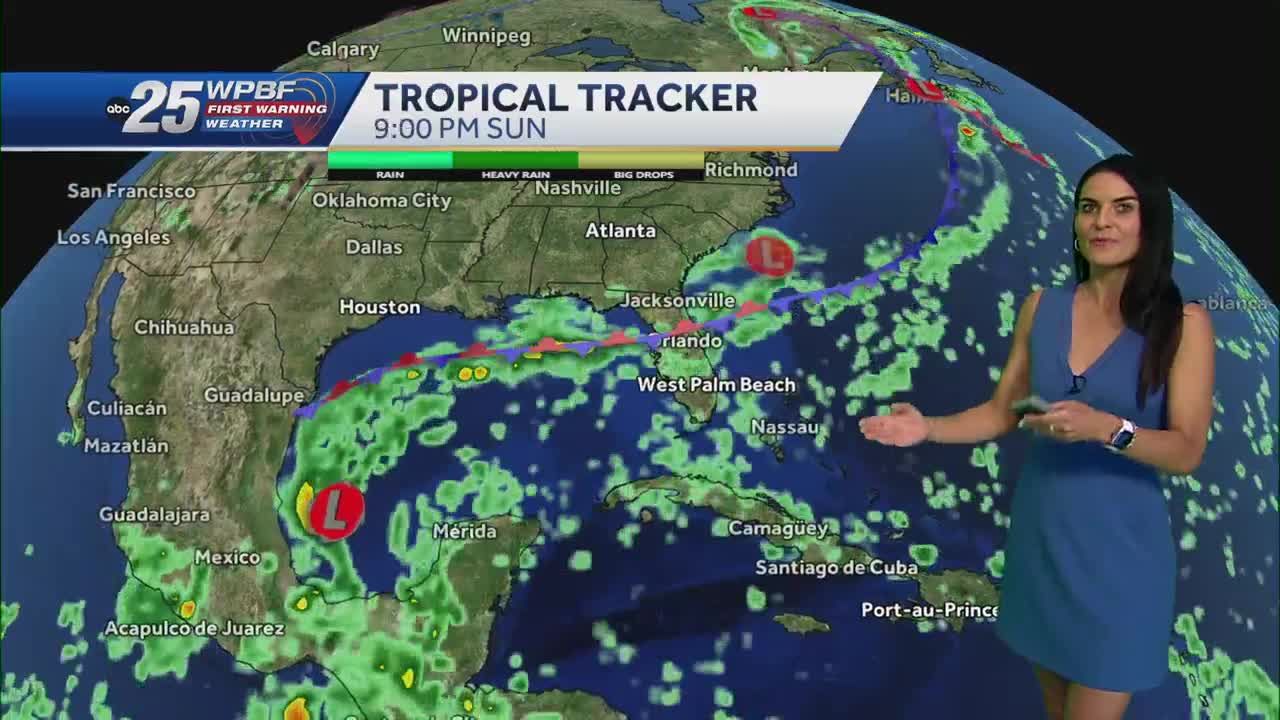
Turning our attention to the tropics, there are several systems we’re monitoring. One area of concern is in the Gulf of Mexico, which has a high likelihood of developing into a tropical depression or even a tropical storm. This system is expected to impact the northern Gulf Coast states later in the upcoming workweek.
Further east, we’re keeping an eye on two other potential tropical disturbances. The first, known as Invest 92-L, is likely to become a depression by midweek. Behind it, another system is also being watched for potential development. While no named storms have emerged yet, there’s a possibility that we could see a system named Francine as soon as Monday or Tuesday. This system might affect the Gulf Coast from Texas to Louisiana by Thursday morning.
For us here in South Florida, it appears we will not face a direct impact from these tropical systems. However, it’s a good reminder to have your hurricane preparedness plan in place, as the season is still in full swing.
Looking ahead, temperatures will remain high with the possibility of passing showers and storms continuing through the week. Expect a mix of upper 70s to low 80s in the mornings, with heat indices pushing towards the 100-degree mark by late morning through early evening. Keep an eye on the weather updates, stay cool, and take necessary precautions to handle the heat.
Read More:


0 Comments