

Coldest Air of the Season to Hit Orlando Area This Thursday
As we brace ourselves for a significant cold front, Central Florida is about to experience its coldest air of the season this Thursday. After days of cooler temperatures, expect a sharp drop that will make it feel much colder, with wind chills pushing the mercury even lower. This Arctic blast is set to continue for the next few days, significantly impacting weather conditions across the region.
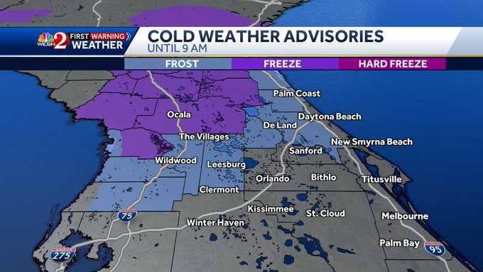
Tonight, temperatures will fall drastically, and by Thursday morning, the chill will be undeniable. Many areas in Central Florida will wake up to freezing conditions, with some parts under a freeze warning. Counties such as Marion, Lake, and Volusia are expected to experience temperatures at or below freezing. For those living in these regions, it's crucial to prepare for dangerous cold, particularly between midnight and 9:00 AM, when the freeze warning will be in effect.
Also Read:- BYD Sealion 7 to Challenge Tesla Model Y with Starting Price Under $60k
- Wizards vs 76ers: A Shorthanded Clash on January 8, 2025
Expect temperatures to start the morning in the low 30s across much of the area. For instance, cities like Reddick and Dunnellon will see temperatures around 29°F, while Ocala will start at 31°F. The Villages and Wildwood will also hover around freezing. Central and southern parts of the area won’t escape the chill either. Places like Sanford and Apopka will see temperatures around 33-35°F, with frost expected in many areas.
But it’s not just the cold temperatures that will make things uncomfortable – the wind chill will make it feel even colder. With gusty winds ranging from 5 to 15 mph, the real-feel temperatures could drop into the 20s, especially early in the morning. So, while the sun may shine brightly tomorrow, it will still feel like a frigid winter day, and residents will need to keep their jackets and coats on throughout the day. The afternoon high will struggle to climb into the 50s, so it’s a day to bundle up and keep warm.
Thursday morning marks the start of what meteorologists are calling "impact weather," which will likely continue into Friday morning. If you plan to head out, remember that temperatures won’t rise much during the day, and the biting winds will keep it feeling much colder than it really is. By Friday, we’ll see a slight warm-up, with highs in the upper 60s and low 70s, as warmer air moves in ahead of another low-pressure system. However, don’t expect the warm-up to last long, as a cold front is expected to bring rain on Saturday, with a 50% chance of precipitation.
It’s a reminder that even in Central Florida, winter isn’t over just yet. The cold temperatures combined with the potential for frost and freeze warnings make tomorrow a day to take extra precautions. Be sure to protect your plants, pets, pipes, and people from the dangerously cold conditions, and if you’re using space heaters, make sure to do so safely.
With this cold snap, it’s best to prepare for the unexpected. Stay updated on the latest weather alerts and be ready to make adjustments to your plans. Whether it’s staying bundled up or protecting your outdoor plants, don’t let the cold catch you by surprise this Thursday.
Read More:


0 Comments