

Polar Vortex to Bring Extreme Cold to Eastern Canada This Weekend
As winter tightens its grip across Canada, a significant weather event is set to make its presence known. A polar vortex is on track to overwhelm Eastern Canada, plunging the region into a deep freeze that will bring some of the coldest temperatures in years. Starting this weekend, this Arctic surge will cause temperatures to plummet, with wind chills potentially reaching dangerously low levels.
The polar vortex, which is essentially a large pocket of frigid air circulating around the North Pole, will shift southward, bringing icy temperatures that will affect much of Eastern Canada. The effects of this weather pattern are already being felt in the Prairies, where temperatures have dropped sharply. In Winnipeg, blizzard warnings are in effect, while cities like Saskatoon, Regina, and Winnipeg will experience daytime highs in the -20°C range, with wind chills pushing those temperatures to a bone-chilling -40°C or lower.
Also Read:- Learner Tien and Gael Monfils Defy Age at Australian Open 2025
- Arctic Blast: Polar Vortex to Freeze U.S. with Extreme Cold from North to South
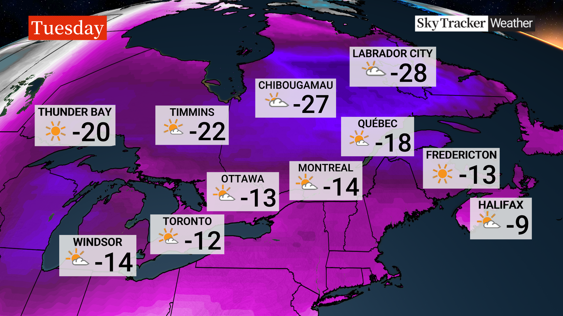
But this cold spell is not confined to the Prairies. As the weekend progresses, this intense cold will make its way across Southern Ontario and Quebec, where a mix of rain and snow will create hazardous travel conditions. By Sunday night, that rain will turn into snow in the Maritimes, adding to the disruption. The coldest temperatures will be felt on Monday and Tuesday, when daytime highs will remain below -20°C for many cities, with wind chills making it feel closer to -30°C to -40°C in some areas.
Environment Canada has issued warnings for extreme cold, urging residents to take precautions to avoid frostbite, which can develop in just minutes when exposed skin is subjected to such low temperatures. The agency advises everyone to stay dry, as wet clothing can worsen the effects of the cold. If you must go outside, bundle up with layers of warm clothing and cover as much skin as possible.
In Toronto and the Greater Toronto Area (GTA), the Arctic surge will arrive on Saturday with a wet snow and rain mix, creating slick conditions on the roads. The real plunge in temperatures will happen by Sunday, when temperatures are expected to fall by as much as 8 to 10 degrees, and wind chills will make it feel much colder. Toronto has already activated its warming centres to help those in need, opening several locations throughout the city for those seeking refuge from the cold.
This extreme cold will extend further south than usual, even threatening U.S. states along the Gulf Coast. The intense cold will affect regions as far south as Texas and Florida, where citrus crops are at risk. In Washington D.C., the inauguration of U.S. president-elect Donald Trump will take place in what is predicted to be the coldest temperatures in 40 years, with wind chills in the minus teens.
While the cold is expected to persist into next week, there is a glimmer of hope. Temperatures will start to moderate toward the end of the week, but experts warn that another blast of frigid air could return by the end of January. This is a reminder to stay prepared for whatever this unpredictable winter has in store.
Read More:


0 Comments