Snowstorm Hits NYC and Tri-State, Accumulating Half a Foot of Snow in Some Areas
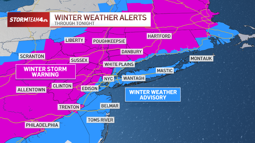
A powerful snowstorm is sweeping across the Tri-State area, with New York City bracing for a significant snowfall on Sunday. The storm is already causing disruptions, as snow has steadily accumulated throughout the region, with totals reaching as high as 6 inches in some areas. The heaviest snowfall is expected to occur between 5 and 9 p.m., with some areas experiencing snowfall rates of up to an inch per hour. The storm is particularly impactful for parts of New Jersey, the Hudson Valley, and northern New Jersey, where snowfall totals could exceed 8 inches, especially in higher elevations.
In the New York City metro area, snow accumulation is expected to range between 3 and 5 inches, but locations further inland could see much higher totals. The snow began in the afternoon but picked up intensity as the evening approached, as temperatures dropped below freezing. This dramatic shift in temperature will lead to icy conditions on roads and sidewalks, making travel hazardous. The storm is part of a larger winter weather pattern that has triggered winter storm warnings for several counties in New Jersey and New York.
Also Read:- Trump Vows Historic Day One with Bold Executive Orders on Immigration and More
- Unlock Your Path with the Stars: Daily Horoscope for January 20, 2025
The National Weather Service has issued warnings for areas along the I-95 corridor, predicting that snowfall could accumulate between 6 to 8 inches, while more remote areas could see even higher amounts. For example, parts of northern New Jersey, the upper Hudson Valley, and Connecticut could experience up to a foot of snow in certain areas. If the snow bands intensify, these totals may be even higher, but if colder air arrives more gradually, snowfall could be on the lower end of the forecast range.
As the storm progresses, the region is also facing a sharp drop in temperatures. While the snow is falling, temperatures will plummet, making it dangerous for travelers. The cold front moving in after the storm means that the snow will not be melting anytime soon. The coldest period of the winter is expected this week, with morning temperatures in the teens and wind chills dipping below zero. This cold snap will last well into the week, creating hazardous conditions and increasing the risk of frostbite and hypothermia.
New Jersey's Governor Phil Murphy declared a state of emergency on Saturday ahead of the storm, urging residents to stay off the roads unless absolutely necessary. The snowstorm is not only affecting road travel but also causing delays at airports and significant disruptions in the region's public transit systems. The MTA has been monitoring the situation closely but has not yet made any major changes to the weekend and holiday schedules. However, commuters are urged to remain cautious as conditions continue to worsen.
This snowstorm, which started early Sunday morning, is expected to last into the evening, continuing to affect areas in New Jersey, New York, and Connecticut. By Monday morning, temperatures will dip to single digits in many parts of the city, with wind chills making it feel even colder. Roadways, especially bridges and overpasses, will be slick and treacherous, so drivers are advised to take extra precautions.
As the storm makes its way through, it's important to stay updated on local weather alerts and avoid unnecessary travel. The storm is expected to clear by Monday, but the dangerously cold temperatures will remain throughout the week, making it crucial for residents to prepare for the brutal conditions ahead. Stay safe and warm as this major winter storm continues to unfold across the Tri-State region.
Read More: