

Weather Network Forecast: February to Bring Major Shift After January's Arctic Blast in Canada
As January comes to a close, Canadians can expect a dramatic shift in weather patterns, transitioning from the Arctic chill that defined the last few weeks into a much warmer, milder February. A major pattern change is on the horizon, and millions of Canadians won’t have to face the extreme cold that has gripped much of the country.
Throughout January, a highly amplified jet stream sent frigid Arctic air into North America, sparking a historic winter storm in the United States and sweeping bitter cold into many regions. While this cold front severely impacted the southeastern United States, the Arctic regions of Canada experienced unusually warm conditions, providing a stark contrast in temperatures. Canadians have still felt the chill, with transient blasts of cold air, especially in southern Ontario and parts of the country over the past week.
Also Read:- Jota Returns to Celtic as Kyogo Joins Rennes – A Dynamic Transfer Shuffle
- Mitchell Owen's Explosive Century Guides Hobart Hurricanes to First BBL Title
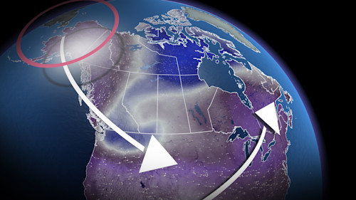
The shift to milder conditions in February will be largely driven by a significant change in atmospheric dynamics. In Western Canada, a ridge of high pressure over British Columbia has played a central role in maintaining dry and mild Pacific air, but this ridge will flatten in the coming days. This will allow a new high-pressure system to form over Alaska, sending Arctic air southwards, particularly into Yukon and the Northwest Territories. This surge of cold air will set the stage for some of the coldest temperatures of the season, with regions like Vancouver and Kamloops expected to see their coldest highs yet.
Eastern Canada, on the other hand, will experience a more gradual transition. While an upper trough of low pressure has kept volatile weather and colder temperatures lingering across northern Quebec and Ontario, a shift will occur as Pacific air pushes eastward into early February. This will offer a brief respite from the cold for many areas in Eastern Canada.
Looking ahead, February is shaping up to be an active month, with an increased likelihood of storms across Canada. The jet stream will remain wavy, drawing systems from the north and bringing periods of snow to regions like Saskatchewan, Manitoba, and Ontario. As the storm track shifts, there’s a chance of rain mixed with snow as the warmer air from the southeast collides with colder air over the Great Lakes and Atlantic Canada. Winter weather will remain a constant, but the fluctuating temperatures will keep Canadians on their toes throughout the month.
As February rolls in, the weather promises to be dynamic and unpredictable, and The Weather Network will continue to keep you updated on the evolving conditions. Make sure to stay tuned for our full February outlook to get all the details on what to expect from this active winter pattern.
Read More:


0 Comments