

Southern Ontario Braces for Snowstorm as U.S. Faces Icy Blast
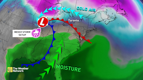
Hey everyone, if you're in Southern Ontario, brace yourselves because another round of winter weather is on the way! While our neighbors south of the border are dealing with a massive 1,500-kilometer stretch of freezing rain, most of Ontario is looking at a more manageable—though still disruptive—snowfall event.
The storm is expected to roll in Wednesday night and continue into Thursday, bringing snow to most of Southern Ontario. Some areas near Lake Erie and into the Niagara region might see a mix of freezing rain, but thankfully, the worst of the ice storm will stay south of the Great Lakes. That being said, travel conditions are still expected to be tricky, especially during Thursday morning and evening commutes. If you have to be on the roads, make sure to check the latest weather updates and highway conditions before heading out.
Also Read:- Naga Munchetty Speaks Out Against Fake Nude Scandal Targeting Her Online
- Jurassic World Rebirth Trailer Unleashes a New Era of Dino Terror
This system is part of a broader pattern where Arctic air is clashing with warmer air to the south, creating an active storm track. And guess what? This is just the beginning. Another storm is on the radar for the weekend, and it could bring even more snow and ice.
For Thursday specifically, snowfall amounts aren’t expected to be too heavy, with most of Southern Ontario getting around 3 to 5 cm. Eastern Ontario could see a bit more, with totals reaching up to 10 cm. The biggest concern is timing—since the snow will be falling during peak commuting hours, we’re likely to see delays and messy road conditions.
Beyond Thursday, we’ll get a brief break on Friday with colder but relatively calm conditions. However, all eyes are on the weekend as a potential Colorado low moves in. This system could bring a mix of snow, ice pellets, and freezing rain, making for another challenging period of winter weather. Some areas could see a significant snowfall, though exact amounts will become clearer as we get closer.
As we move into next week, temperatures are expected to stay colder than normal, and the active weather pattern will likely continue. So, if you were hoping for an early taste of spring—thanks to La Niña and the polar vortex, that might not be happening anytime soon.
For now, stay safe, stay warm, and keep an eye on the latest weather updates. If you’re driving on Thursday, give yourself extra time and be prepared for slippery conditions. Winter isn’t done with us yet!
Read More:


0 Comments