

Tornado Warning in Lexington, KY: Severe Storms Expected Tonight
Folks, we have a serious weather situation unfolding across Lexington and the surrounding areas. A tornado warning has been issued as we brace for a powerful storm system set to move in late tonight. If you’re out and about right now, it’s time to start preparing and making plans to stay safe.
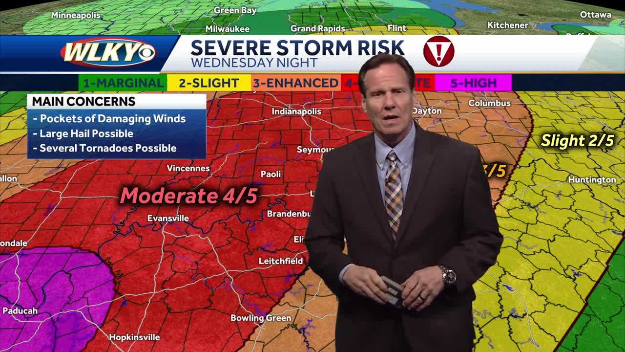
We’ve had a warm, windy, and humid day leading up to this event, with temperatures peaking in the low 80s. But as we move deeper into the evening, conditions are rapidly shifting. Radar scans are still clear for now, but that won’t last long. Storms are already developing in Illinois, Missouri, and Arkansas, and they’re heading our way. Some of these storms are showing supercell characteristics, meaning they have the potential to produce damaging winds, large hail, and, yes, tornadoes.
As of now, tornado watches have been issued for areas just west of us, but experts expect additional watches and warnings to be announced as the evening progresses. The highest risk is for strong winds, flash flooding, and tornadoes developing out ahead of the main storm line. Some of these storms could be long-track tornadoes, meaning they could stay on the ground for an extended period, causing significant damage.
Also Read:- Remembering Mark Laforest: AHL Champion and Former NHL Goalie
- Rachel Maddow, We Need You Five Nights a Week
The timing is crucial. Expect conditions to worsen between 8:00 and 9:00 PM, with scattered storms popping up ahead of the main line. These isolated storms will be capable of producing tornadoes and large hail. The main line of storms will arrive around midnight, hitting northwestern parts of our region first and then sweeping through central Kentucky overnight. By the early morning hours, the storms will be moving southeast, bringing heavy rain and severe thunderstorms to a broader area.
A particular concern tonight is flash flooding, especially for communities in the southern part of our region. As the front slows down and stalls, waves of heavy rain will continue, leading to potential flash flooding in low-lying areas. Some spots could see between 6 to 10 inches of rainfall by the end of this weather event, increasing the risk of both river flooding and flash flooding through the weekend.
This is just the beginning of what looks to be an extended period of severe weather. Multiple rounds of storms are expected through Sunday, with heavy rain, strong winds, and continued flood risks. If you live in a flood-prone area, take necessary precautions now. Stay tuned to local weather updates and have your emergency plans in place. If a tornado warning is issued for your area, seek shelter immediately in a sturdy, enclosed space away from windows.
The good news? We do see a break in the pattern early next week, with cooler and calmer conditions settling in by Tuesday. But until then, we have a rough few days ahead.
Stay alert, stay safe, and keep your weather radios and phones handy for any emergency alerts. We’ll continue to provide updates as this severe weather event unfolds.
Read More:


0 Comments