

Houston Braces for More Storms as Flood Risks Rise Across Southeast Texas
Hey everyone, just a quick update on what’s going on with our weather here in Houston—it’s been a stormy few days, and unfortunately, it’s not over yet. Today’s forecast is keeping us on high alert as another round of heavy rain and potentially severe storms makes its way through Southeast Texas. If you're heading out today, you’re definitely going to want to stay weather-aware.
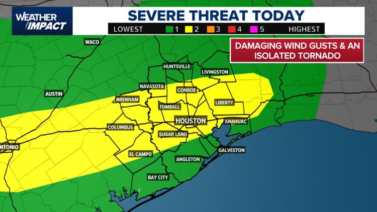
Starting late this morning, we saw widespread showers and storms building across the region. The first wave came through between 10 a.m. and noon, but it’s the second round, expected from noon to around 7 p.m., that’s got the meteorologists issuing alerts. That’s right during the afternoon commute, so be careful on the roads. It’s not just rain we’re talking about—there’s a slight risk (Level 2 out of 5) for severe storms, which means damaging wind gusts, localized flooding, and even the chance of an isolated tornado aren’t off the table.
Also Read:- Reflecting on Brian Wilson's Legacy and Mike Love's Complex Role
- Harvey Weinstein Convicted Again in New York Retrial Amid Jury Tensions
Now, street flooding is a big concern. Some areas are already waterlogged from earlier rainfall this week, and the ground just can’t soak up much more. So when that heavy rain comes down quickly, it pools up fast—especially in those low-lying spots we all know too well. Places like Conroe, Sugar Land, Liberty, El Campo, and basically the entire Houston metro are under that same Level 2 warning for severe storms.
If you're north and west of the city—think Brenham, Huntsville, Austin—you might actually be in a moderate flood risk zone. That means the potential for rapid water rise is even greater, so again, don’t take chances with flooded roads. As meteorologist Pat Cavlin reminded us: “You know the drill—don’t drive through high water.” That simple rule has saved lives before.
The storm pattern isn’t letting up after today, either. Thursday is looking like another very wet day, with widespread rain forecast and some areas expected to get between 2 to 4 inches—isolated totals up to 6 to 8 inches are even possible. So yeah, this isn’t just your average summer thunderstorm setup.
There is a bit of good news on the horizon though. While Friday may still bring some scattered showers, the weekend is trending drier, and there’s no tropical development expected in the Gulf for at least the next seven days. Father’s Day on Sunday could bring a break from the rain, although temps will be climbing back into that muggy, early summer heat.
For now, make sure your phone alerts are turned on, prep any errands before the storms really ramp up, and keep an eye on your local radar apps. Let’s all stay safe, look out for each other, and ride out this stormy stretch together. Houston’s seen worse—we’ll get through this too.
Read More:


0 Comments