

Rare and Violent Thunderstorm System Set to Slam Quebec Tonight
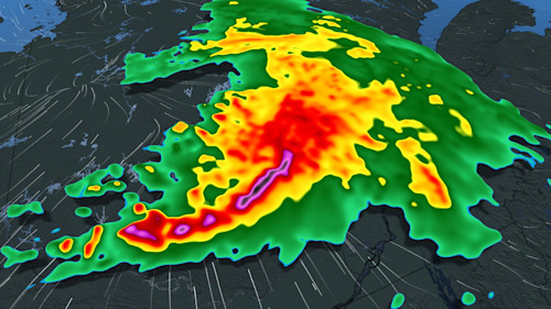
Right now, Quebec is on high alert. A severe weather system—something meteorologists rarely see in this region—is making its way across the province this evening. It’s not just any storm front; this is what’s called a mesoscale convective system, or MCS. That means we’re not talking about a single thunderstorm—this is an organized, sprawling complex of storm cells stretching across hundreds of kilometers, packing the potential for torrential rain, damaging wind gusts, and even tornadoes.
This massive system originated in the U.S. Great Plains and began pushing into Quebec earlier today. By this afternoon, its more intense storm cells had already been targeting areas around Lake Superior. Now, it’s heading directly into some of Quebec’s most densely populated regions, just as night falls—when visibility drops, and tracking individual storm cells becomes much harder.
Also Read:- Canada Faces Curaçao with Quarterfinals in Sight at the Gold Cup
- Santi Cazorla’s Magical Night as Real Oviedo Returns to La Liga After 24 Years
What makes this system particularly dangerous is the atmospheric setup. The storm is riding a hot air mass that’s been building over the eastern United States, creating what meteorologists call a “ring of fire.” This dynamic allows for extreme instability, fueling the kind of explosive storm development we’re now seeing.
Areas like Abitibi-Témiscamingue are already under serious threat, with violent conditions expected as early as late this afternoon. From there, the risk stretches across central and southern Quebec—including the Greater Montreal area, Outaouais, the Laurentians, and Estrie. The most active part of this system could sweep through overnight into early Sunday morning, when it's much harder for people to respond quickly.
And here's something to keep in mind: the last time a storm of this nature made a widespread impact in Quebec was back in May 2022, when a derecho tore through from Ontario to the province, leaving destruction in its wake. Derechos are fast-moving thunderstorm complexes that travel over 400 kilometers with sustained wind gusts over 90 km/h. While it’s too early to confirm if tonight’s event will qualify as a derecho, the setup certainly has some of the telltale signs.
Already, heavy rainfall amounts of up to 75 mm are being forecasted in some regions, and strong winds are expected to down trees and possibly cause power outages. In fact, Montreal and Outaouais could be in for a very rough night. Officials are urging people to secure outdoor furniture, close umbrellas, check windows, and avoid camping or being on the water during these volatile hours.
If you remember the chaos of past violent weather events in the province, this is not the time to take warnings lightly. We’re witnessing a convergence of rare meteorological factors, and the consequences could be significant. Stay alert, monitor weather updates, and take every precaution necessary. Tonight might not just be stormy—it could be historic.
Read More:


0 Comments