Severe Storms Slam North Texas with Damaging Winds and Flash Floods
Hey everyone, here’s what’s happening right now in North Texas—this is a serious weather situation you need to be aware of. We are currently under multiple severe weather warnings, and the impact is being felt across the Dallas-Fort Worth metroplex and beyond.
Last night, a powerful line of storms rolled through North Texas, bringing with it intense wind gusts—some reaching speeds over 80 miles per hour. These aren’t just ordinary storms; this system has been classified by the National Weather Service as a Particularly Dangerous Situation , which is rare and reserved for weather events that pose significant threats to life and property. Winds of this strength can cause damage similar to a low-end tornado, taking down trees, damaging roofs, and leaving thousands without power.
Also Read:- FightMND Goes Digital with Beanies to Drive MND Awareness and Research
- Greta Thunberg's Gaza Aid Mission Blocked by Israeli Forces
Flash Flood Warnings are in effect across several counties including Dallas, Tarrant, Collin, and Denton. Streets in downtown Dallas are already underwater in places, with cars stranded and emergency services performing rescues. Dallas Fire-Rescue was on the scene overnight helping stranded drivers near Live Oak Street. Thankfully, no injuries have been reported from those incidents.
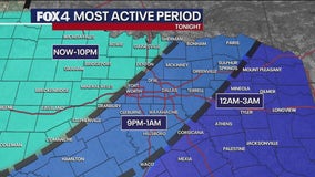
As for the forecast, these storms are expected to linger into the early hours, with the most intense weather pushing through between 10 p.m. and 2 a.m. A Severe Thunderstorm Watch remains in effect until 4 a.m. for most of the region, covering more than a dozen counties from Red River to Johnson. The primary concern continues to be strong straight-line winds, but isolated tornadoes and large hail are also possible.
Governor Greg Abbott has activated the state’s emergency response resources in anticipation of flooding and storm damage. That includes everything from swift water rescue teams to the Texas National Guard and high-water vehicles. The Texas Department of Public Safety is also mobilizing helicopters with hoist capabilities to assist in potential rescues.
Officials are urging all residents to stay alert and prepared. Keep multiple sources of weather alerts active—don’t rely on just one method. If you're out tonight, turn around, don’t drown . Floodwaters can rise quickly and be deceptively deep. Secure loose outdoor items and stay away from windows during high winds.
This storm has the potential to be one of the most impactful we’ve seen this season in North Texas. With the ground already saturated and more rain expected through the week, the flood threat will only grow. We could be looking at multiple rounds of storms from Tuesday to Thursday.
So please, take this seriously. Monitor local updates, follow instructions from emergency services, and stay indoors if you can. Stay safe out there, North Texas.
Read More:

0 Comments