

Southern Quebec Braces for Severe Thunderstorms with Hail and Violent Winds
Right now, all eyes are on southern Quebec as the region finds itself once again in the crosshairs of a major weather threat. We’re entering the third straight day of storm activity across the province, and Thursday is shaping up to be particularly intense. From early morning, signs were already pointing toward severe instability in the atmosphere. A cold front making its way toward the St. Lawrence River has set the stage for thunderstorm development across much of the south.
By 9 a.m., weather alerts were already being issued—starting with Thetford Mines and shortly after, spreading to Joliette, L’Assomption, and Otterburn Park. Residents of Chaudière-Appalaches witnessed something quite alarming: hailstones of truly remarkable size pounding the area, a clear indicator of the storm’s strength. Photos shared from Saint-Benjamin show chunks of ice that easily met the criteria for severe storm classification.
Also Read:- Raging Wildfires Force Thousands to Flee in Crete as Europe Boils Under Heatwave
- Bulldogs Dominate as Roos Mark 100-Year Milestone in Marvel Showdown
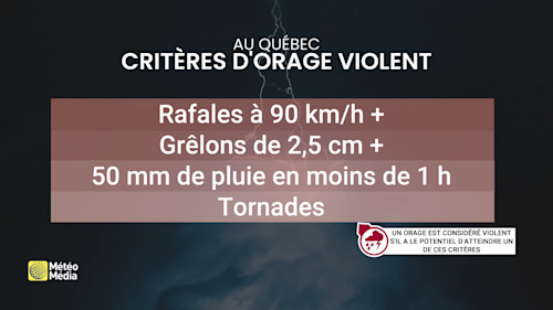
The threat isn’t isolated. As we move into the afternoon and temperatures rise, reaching a humidex of 28°C or more, the entire region south of the St. Lawrence is expected to feel the brunt. There’s an abundance of energy in the atmosphere, particularly across Estrie, Beauce, the southern areas of Quebec City, Bas-Saint-Laurent, and extending all the way to Gaspésie. The concern is that this energy could fuel supercell development—storms that bring not only torrential rain and dangerous lightning but also damaging wind gusts that might top 90 km/h.
One alarming report from Chaudière-Appalaches suggested hail as large as a baseball—yes, you heard that right. That type of hail can damage cars, roofs, windows, and even injure anyone caught outside. The storm cell responsible for that destructive episode has since crossed into Maine, but similar conditions are expected to recur across multiple Quebec regions today.
Power outages have already been reported—Coaticook, Cowansville, and Frelighsburg all experienced electrical disruptions due to strong winds and possibly falling trees or power line interference. Authorities have emphasized the importance of staying indoors, especially during peak storm periods. Water activities should be avoided entirely; wind gusts over water can become deadly with little to no warning.
Though humidity levels are slightly lower than previous days, don’t be fooled—this doesn't reduce the risk of flash flooding or severe storm impacts. The intensity of rainfall remains a threat, and fast-forming storm cells can still dump large amounts of water in short periods.
We’re continuing to monitor the situation as it unfolds, but it’s clear—southern Quebec needs to stay alert. From grêle the size of baseballs to intense gusts and downpours, today isn’t just another rainy summer day. It’s a day to take weather warnings seriously. Stay safe, stay informed, and if a storm warning is issued in your area, take shelter immediately.
Read More:


0 Comments