

Freezing Rain to Create Hazardous Travel Conditions in Southern Ontario this Weekend
As we enjoy the mild and sunny start to the weekend, southern Ontario is about to face a dramatic shift in weather that will bring rain, freezing rain, and even some snow by Sunday. This change is set to impact travel and outdoor plans, as a weather system moving in from the United States will lead to icy conditions and slippery surfaces across the region.
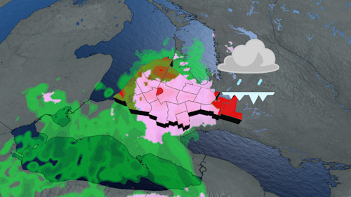
The calm, clear skies of Saturday will soon be replaced by cloudy, rainy weather, with a high potential for freezing rain and drizzle affecting areas from Lake Huron to the northern Greater Toronto Area (GTA). Starting Sunday afternoon, the freezing rain or drizzle may cause light ice accretion on various surfaces, including roads, highways, sidewalks, and parking lots, making travel hazardous. While the rain will start as a mild shower, temperatures dropping to near freezing will create conditions that are ideal for ice to form, leading to slippery travel conditions. Drivers are urged to slow down, exercise caution, and avoid unnecessary trips if possible, especially in areas under special weather statements.
Also Read:- Alavés vs Athletic: Intense Derbi Vasco with Unai Gómez's Early Goal
- Ruben Amorim Explains Shocking Exclusions of Rashford and Garnacho Ahead of Derby
In southwestern Ontario, regions like Windsor will see rain showers begin Sunday morning, gradually spreading to areas like London by the afternoon. As temperatures hover near the freezing point, there is a risk of mixed precipitation—rain transitioning into freezing rain or snow, creating dangerous conditions on untreated surfaces. As the freezing rain continues into the evening, it will gradually turn into drizzle as temperatures rise above freezing, easing some of the dangers on the roads, but not before creating potential delays for travelers.
The system bringing this icy weather is expected to move out by Monday morning, when milder temperatures will quickly melt any ice accumulation, leaving behind wet and muddy roads. But the transition will not be smooth. Another cold front will push into the region later in the week, bringing the possibility of colder, snowier weather. While the forecast for Christmas week suggests milder temperatures, there is a growing likelihood that the first half of January could bring extended cold spells and harsher winter conditions.
For now, residents in southern Ontario should prepare for a tricky Sunday with mixed precipitation, especially if they need to be on the roads. With freezing rain and icy conditions expected, it’s vital to stay informed through updated weather reports and plan your travels carefully. Stay safe and monitor your local forecasts as conditions continue to evolve over the weekend.
Read More:


0 Comments