

Light Snow and Frigid Temperatures Hit Oklahoma: What to Expect
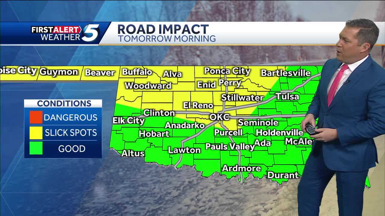
Oklahoma is currently experiencing a wintry mix that includes light snow and a significant drop in temperatures. A small band of snow has been making its way through central parts of the state, including Oklahoma City, and while the snow is expected to taper off soon, the arctic cold will continue to linger. This cold snap is affecting not just central Oklahoma, but the entire state. While the snow has been light, it is expected to cause some travel disruptions, particularly on neighborhood streets. These areas may see slick spots that could create hazardous driving conditions. However, main roads should remain relatively clear as the snow is light and powdery in nature, blowing around but not accumulating heavily.
The cold air that has settled in is another concern. Temperatures in Oklahoma City are currently in the low teens, and the wind chill is making it feel even colder. It’s expected to feel like -1°F by early Tuesday morning in Oklahoma City, with temperatures plummeting even lower in the northern parts of the state. Cities like Buffalo are already experiencing wind chills that are 17°F below zero, making it dangerously cold. The bitter cold combined with the wind will make conditions uncomfortable, especially in the morning when temperatures will be well below freezing. A low of 10°F is forecasted for tonight in Oklahoma City, and it’s expected to only warm up to around 32°F tomorrow, which is still well below average for this time of year.
Also Read:- Trump’s Bold Executive Orders on Day One: Renaming Denali and More
- Lauren Sánchez Turns Heads at Trump’s Inauguration with Bold Fashion Choice
For those with plans tomorrow morning, be aware that road conditions could be tricky, especially on less-traveled streets. While main roads are expected to remain clear, areas further north could see snow accumulation of up to an inch. Parts of the Panhandle might even see 2 to 3 inches, but overall, this won’t be a major snowstorm, just enough to make driving a bit more challenging. Despite the snow’s light nature, any accumulation could lead to icy conditions, particularly in areas that are not treated by road crews. Travel disruptions could continue into the evening as temperatures remain low.
The cold snap is expected to last throughout the week, but there is some relief on the horizon. By Wednesday, temperatures are forecasted to climb into the mid-40s, helping to melt the snow and warm things up a bit. However, the cold weather won’t completely disappear, with highs in the 40s and lows in the 20s still expected for the rest of the week.
Looking ahead, it’s important to prepare for these cold conditions, as the arctic blast has a grip on the state. Ensure that you bundle up, check on loved ones and pets, and be mindful of potentially slick roads, especially on neighborhood streets. While the snow may not be substantial, the cold temperatures will be a lasting issue. So, stay tuned to local weather updates for the latest on the changing conditions and be prepared for more winter weather in the coming days.
Read More:


0 Comments