

Surprise Spring Snowstorm to Hit NYC Suburbs This Weekend
Hey everyone, can you believe this? We’re halfway through April, and guess what’s back on the radar— snow . Yeah, that’s right. Mother Nature’s clearly not ready to let go of winter just yet, and the Tri-State area is bracing for another unexpected round of wintry weather. So if you were thinking of packing away those coats and boots, you might want to hold off a little longer.
Also Read:- Tony Hadley Fears His Wife May Never Forgive Him for Skipping Their Honeymoon
- Shubman Gill and Sai Sudharsan Light Up IPL 2025 as Gujarat Titans Dominate LSG
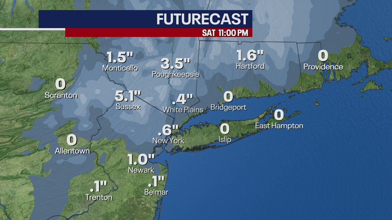
According to meteorologists and the National Weather Service, a storm system is pushing up from the south and will sweep across the Northeast late Friday into early Saturday. Rain is expected to begin Friday evening, and as temperatures drop into the 30s, that rain will transition into snow in some northern suburbs. Orange and Putnam counties in New York are under a Winter Weather Advisory starting around 2 a.m. Saturday. That advisory is expected to lift by 10 a.m., but by then, the snow will have made its mark.
Now, before we start panicking, this isn’t going to be a full-on blizzard. Most areas in those counties are forecasted to get about 1 to 2 inches of snow, but if you're in higher elevations—like 750 feet and above—you could see anywhere between 2 to 3 inches. Some isolated spots might even get up to 5 inches. Parts of New Jersey, including Passaic County, and sections of Connecticut like Fairfield and New Haven counties could also get a similar snowfall, especially in elevated areas.
Back in the city, it’s mostly going to be cold and rainy . NYC proper likely won’t see much snow accumulation, but don’t be surprised if it’s dreary and wet for most of Saturday. Temperatures are staying stuck in the low 50s and even dropping into the 40s during the overnight hours. It’s one of those weekends where you’ll want to keep a mug of something warm nearby and maybe rethink those outdoor plans.
The bigger picture? A persistent low-pressure system and a dip in the jet stream are dragging this weather our way, and it’s not just this weekend. NOAA’s Climate Prediction Center says we could be stuck in a chilly, damp pattern for the next 8 to 14 days. So yeah, spring seems to be on vacation at the moment.
Bottom line: If you're in the outer suburbs, especially in the Hudson Valley or western New Jersey, prepare for slick roads and that classic slushy mess. Give yourself extra time in the morning and drive carefully. For the rest of us, it's umbrellas up and layers on. April may be known for showers, but this year, it's bringing snow with it too.
Stay warm, stay safe, and keep checking for updates—this spring storm might just surprise us all.
Read More:


0 Comments