

Storms Stir Up the Southeast: Be Prepared for Round Two
Hey everyone, just a quick weather check-in for today—because if you’ve stepped outside lately, you know the skies have had a lot to say. Yes, we’re talking about those isolated thunderstorms again. And while they may seem familiar at this point, like a repeating scene from Groundhog Day , don’t let the pattern fool you—some of these storms are packing a real punch.
We’ve still got a stubborn low-pressure system sitting just to our west, and that’s continuing to churn out showers and thunderstorms across the region. Areas like Clemson, Greenville, Spartanburg, and Gaffney have already picked up quite a bit of rain this morning. And it’s not done yet.
Also Read:- Chris Brown Arrested in UK Over 2023 Nightclub Assault Allegations
- Godden's Late Strike Sends Charlton to Wembley Dream
Throughout the afternoon and into the evening, we’ll see a handful more thunderstorms roll through. Most of them will be scattered, but some could be severe. What should you watch out for? The usual suspects: strong winds, isolated hail, and the real wildcard—flash flooding. With the ground already saturated from days of downpours, it won’t take much more for localized flooding to become a serious concern.
Now, there is some good news. We’re expecting a bit more dry time between those scattered storms today. That should give the ground a chance to breathe and absorb some of the water that’s already fallen. But still—if you're headed out, keep an eye on the skies. These storms may be isolated, but they’re intense. Think of them as short, sharp punches from Mother Nature.
Over in Greenwood, the damage from earlier storms is still visible. A severe thunderstorm knocked down a large tree and power lines at Grace Street and Cambridge Avenue. Crews are actively working to clear the debris, but there’s no official timeline for reopening that intersection. It’s another reminder of how quickly conditions can change—and why we should never underestimate these weather systems.
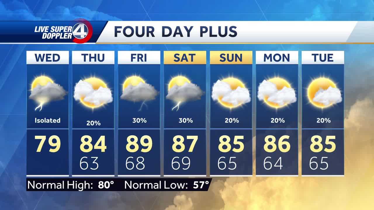
As we look ahead, things are heating up—literally. Tomorrow will bring a break from most of the rain, with partly cloudy skies and temperatures reaching into the mid-80s. By Friday? Near 90 degrees and thick humidity that’ll hit you the moment you step outside. It’s that classic “air you can wear” feel we know too well in the South.
And while the weekend brings the possibility of a few more showers to cool things down slightly, don’t expect much relief from the mugginess. The unsettled weather pattern looks like it’s here to stay into next week unless a strong cold front pushes in—and right now, there’s no sign of that happening anytime soon.
So for now, stay weather-aware. Keep your umbrellas close, stay off flooded roads, and watch for those sudden storm bursts. Whether it’s a sprinkle or a storm, it’s always better to be prepared than caught off guard. Stay safe out there.
Read More:


0 Comments