

Tropical Storm Chantal Targets Carolina Coast with Heavy Rain and Coastal Risks
Hey everyone, let’s talk about what’s happening right now with Tropical Storm Chantal. If you're in South Carolina or North Carolina—or have loved ones in those areas—you’ll want to pay close attention.
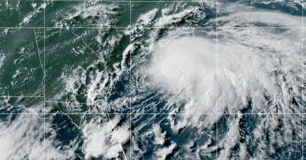
Chantal officially strengthened into a tropical storm early Saturday morning, forming about 150 miles off the South Carolina coast. As of late Saturday night, it had sustained winds of around 50 mph and was moving slowly northward at about 8 mph. It’s currently expected to make landfall early Sunday somewhere between Charleston, South Carolina, and Cape Fear, North Carolina. Once it hits the coast, the storm is forecast to curve northeast and move across the Carolinas, likely weakening as it travels inland.
Also Read:- Smart Money Moves in Uncertain Times: From Savings to Mortgages
- John Cena Confirms WWE Farewell Match Timeline, Sparking Emotional Reactions
Let’s be clear—while this isn’t expected to be a long-lived or devastating hurricane, the storm is definitely bringing some serious weather. Coastal areas between Myrtle Beach and Wilmington are bracing for storm conditions, including dangerous surf and waves as high as 8 to 9 feet. There’s already concern about beach erosion and localized flooding due to heavy rains and persistent high tides.
Rainfall totals could range from 2 to 4 inches across much of the Carolinas, with some areas seeing as much as 6 inches. This sets the stage for flash flooding, especially in low-lying areas and places with poor drainage. Some parts of the eastern Piedmont Triad, especially east of I-40 and I-85, might experience strong downpours from late afternoon into the evening on Sunday. Driving conditions could quickly become hazardous with ponding water and the risk of hydroplaning.
Winds are another factor—not hurricane-force, but gusts could range anywhere from 30 to 50 mph in some coastal regions. That’s enough to bring down weak tree limbs and cause isolated power outages. Inland, the winds will be more manageable, with occasional gusts and breezy conditions during showers and storms.
Now, let’s zoom out a bit. Chantal is part of what’s shaping up to be a very active Atlantic hurricane season. NOAA has predicted a 60% chance of an above-normal season, with as many as 13 to 19 named storms. Up to 10 of those could strengthen into hurricanes, and several might reach major hurricane status. We’re still early in the season—peak activity doesn’t usually hit until mid-August—so Chantal could be a sign of what’s to come.
Bottom line: if you’re anywhere in the Carolinas this weekend, keep your phone charged, stay tuned to weather alerts, and avoid unnecessary travel during heavy rain bands. The storm may not be catastrophic, but it’s got enough punch to disrupt plans and potentially create dangerous conditions, especially overnight and through early Sunday. Be cautious, stay safe, and let’s hope Chantal passes quickly with minimal impact.
Read More:


0 Comments