

Florida Braces for Tropical Depression 14 as Hurricane Helene's Aftermath Lingers
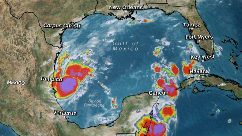
Florida is sounding the alarm as Tropical Depression 14 brews in the Gulf of Mexico, just days after Hurricane Helene wreaked havoc on the state. Formed early Saturday morning, this new tropical depression is anticipated to strengthen into Tropical Storm Milton within the next 24 hours, according to the National Hurricane Center (NHC). Alarmingly, this would mark the 13th named storm of the season, a phenomenon that typically doesn't occur until late October.
Meteorologists are closely monitoring the system, which is expected to move quickly across the Gulf, intensifying as it heads toward the Florida Peninsula. The NHC predicts that the depression could reach or exceed major hurricane status by the time it approaches the state's west coast mid-week. Forecast models show a strong consensus that the storm will continue its eastward trajectory, with landfall likely on Wednesday.
Also Read:- Late Drama as Sunderland and Leeds Draw in Thrilling 2-2 Encounter
- Crystal Palace vs. Liverpool: Match Highlights and Reactions
As anticipation builds, residents along the coast should prepare for potential hurricane watches and storm surge alerts that are expected to be issued by Sunday. Heavy rains could begin to drench parts of Mexico and Florida in the coming days, with predictions of significant rainfall totals across the Sunshine State. The National Hurricane Center warns that this storm could bring locally heavy rains, exacerbating an already dire situation following the recent devastation caused by Hurricane Helene.
Helene, which made landfall on September 26 as a Category 4 hurricane, left a catastrophic mark, resulting in severe flooding, damaging winds, and widespread power outages. Tragically, authorities have reported over 200 fatalities across multiple states, and there are concerns that this number may rise. Helene has been described as one of the largest storms the Gulf of Mexico has experienced in the last century, setting the stage for further complications with the arrival of Tropical Depression 14.
Forecasts suggest that Florida could see widespread rain totals of 4 to 6 inches, with isolated areas receiving up to 10 inches by Thursday. Cities such as Tampa, Melbourne, and Fort Myers have already reported significant rainfall, contributing to an increasing risk of flash flooding and storm surge for the western coast as early as late Tuesday or Wednesday.
Wind damage, tornadoes, and waterspouts are also on the radar as this system approaches. Residents from the Yucatan Peninsula to the Florida Keys and even the Bahamas should remain vigilant and keep a close watch on updates regarding this developing situation. As we prepare for the possibility of yet another storm hitting Florida, the urgency for communities to stay informed and ready cannot be overstated.
Read More:


0 Comments