

Tropical Storm Chantal Set to Make First U.S. Landfall of the 2025 Hurricane Season
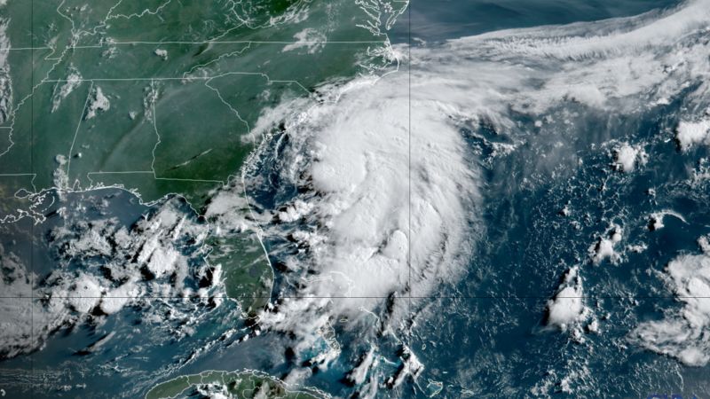
Right now, all eyes are on Tropical Storm Chantal, which formed early Saturday just off the southeastern coast of the United States. It’s officially the third named system of the 2025 Atlantic hurricane season—but it’s the first one that's directly impacting the U.S., and it's grabbing attention, especially as it approaches the Carolina coastline.
As of Saturday afternoon, Chantal’s center was located about 100 miles off the coast of Charleston, South Carolina. Forecast models from the National Hurricane Center show the storm slowly creeping toward land, with expectations that it could make landfall sometime early Sunday morning—most likely somewhere between Charleston and Myrtle Beach. Even though it’s not projected to become a major hurricane, Chantal still carries the potential to disrupt the July 4th holiday weekend with heavy rainfall, gusty winds, and rough surf conditions.
Now, in terms of strength, as of 8 a.m. Eastern on Saturday, Chantal had sustained winds of around 40 mph (64 km/h). Some slight strengthening is expected overnight before it reaches the coast. Tropical storm warnings have already been issued for parts of South and North Carolina, and officials are urging residents and beachgoers to stay cautious—especially with dangerous rip currents and high surf expected throughout the weekend.
Also Read:- John Cena Confirms WWE Farewell Match Timeline, Sparking Emotional Reactions
- Tropical Storm Chantal Targets Carolina Coast with Heavy Rain and Coastal Risks
Rainfall could be one of Chantal’s biggest impacts. Forecasters say the storm could dump anywhere from 2 to 4 inches (50 to 100 mm) of rain across parts of both Carolinas, with some isolated spots possibly seeing up to 6 inches (150 mm). This could trigger localized flooding in low-lying areas, especially in places with poor drainage or recent heavy rains.
There’s also a risk of minor storm surge, with sea levels rising 1 to 2 feet (30 to 60 cm) in certain coastal zones where the wind is blowing inland. While it’s not a catastrophic event, it’s enough to cause beach erosion and temporarily flood vulnerable areas.
Interestingly, while the Southeast prepares for a soggy weekend, much of the rest of the country is enjoying calmer weather. The Northeast and West, in particular, are expected to have clear skies and pleasant conditions—good news for holiday festivities outside of the storm’s reach.
This storm is also arriving at a time when parts of the country are still reeling from recent extreme weather events. Just a day before Chantal formed, devastating floods in Texas claimed dozens of lives and left many communities underwater. It’s a reminder that this hurricane season could be both active and unpredictable.
So as Chantal edges closer to the U.S., it’s crucial to stay informed and prepared—even for storms that aren’t major hurricanes. The Atlantic season is just beginning, and Chantal might be a sign of more to come. Stay safe, especially if you're in the Carolinas this weekend.
Read More:


0 Comments