

Severe Thunderstorm Watch Issued as Multi-Hazard Storm Threatens U.S.
Hey everyone, we’ve got some serious weather heading our way, so let’s talk about what’s happening and what you need to know to stay safe. A massive spring storm is making its way across the country, bringing a dangerous mix of severe thunderstorms, tornado threats, and even fire risks in some areas. The National Weather Service (NWS) has classified this as a "multi-hazard storm," which means different regions are facing different extreme weather conditions all at once.
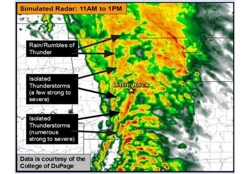
Starting in the Central Plains and moving through the Midwest towards the Great Lakes, this storm is packing intense thunderstorms, damaging winds, large hail, and even the potential for multiple tornadoes. As we head into the evening and overnight hours, the situation is expected to worsen, especially in parts of the southern and central Plains. If you live in these areas, stay alert and have a plan in place in case severe weather strikes.
But that’s not all—this system is also bringing heavy snowfall and strong winds to the Midwest, including Nebraska and surrounding areas. Whiteout conditions could make travel extremely dangerous, with reduced visibility and snow-covered roads. If you don’t have to be on the road, it’s best to stay put.
Also Read:- Brooke Warne’s Emotional Tribute to Father Shane on His Third Death Anniversary
- Vegas Golden Knights Sign Kai Uchacz to Entry-Level Contract
Meanwhile, in the South, including states like Louisiana, Mississippi, and Alabama, the risk of tornadoes, destructive winds, and large hail remains high through Tuesday and Wednesday. Eastern states like Virginia could also see severe weather as the storm progresses. The Gulf Coast is particularly at risk, with damaging winds and heavy rain increasing the chances of flash flooding.
And let’s not forget the critical fire weather conditions in parts of Texas, Oklahoma, New Mexico, and the Carolinas. Strong winds, dry conditions, and low humidity are creating the perfect setup for wildfires to spread rapidly. Red flag warnings are in effect , meaning even a small spark could lead to a dangerous blaze. In North Carolina alone, nearly 200 fires are currently burning, with thousands of acres already scorched.
Wind advisories are also in place across the South and Southeast, with gusts reaching up to 55 mph. If you’re in these areas, be mindful of flying debris, difficult driving conditions, and possible power outages.
Bottom line—this storm is no joke. If you’re in an area under a severe thunderstorm watch, tornado warning, or fire weather alert, stay informed. Make sure you have multiple ways to receive emergency alerts, like weather apps, NOAA radios, or local news updates. Prepare for power outages, secure any loose outdoor items, and have an emergency plan in place for you and your family.
Stay safe out there, and keep an eye on the latest updates. If you’re in the path of this storm, take precautions now—better safe than sorry!
Read More:


0 Comments